The DMZ (Demilitarized Zone) was established to allow for border fortification between communist North Korea and non-communist South Korea. It also aims to keep what could be constant skirmishes at the border to a minimum. A few quick facts. The DMZ is 155 miles (250 km) long running the across the entire Korean peninsula and 2.2 miles (4km) wide.

A map of the DMZ depicting the JSA (Joint Security Area) where North Korean and South Korean officials meet for negotiations. It’s also the area where North and South soldiers stand face to face with each other. Taken during a briefing given to us by the U.S. Army.

The first stop on our tour was Imjingak Park, the place where many Koreans come to pay their respect for dead or missing family members from the Korean War. Freedom Bridge where 13,000 South Koreans re-entered their homeland after being held as prisoners of war.

This makeshift memorial along the DMZ fence keeps civilians (even Koreans) outside the DMZ. Only those taking organized tours are allowed access inside the DMZ.

Peace Bell at Imjingak Park. One can feel the heartbreak of an entire country ripped in two by a brutal war while visiting Imjingak Park.

This was the most poignant moment for me; it literally brought tears to my eyes. This group of Korean soldiers joined hands in a show of solidarity while walking through the monuments at Imjingak Park.

After some lunch of Popeye’s Chicken, we continued on to Observation Point Dora.

Perched on a hill, the binoculars at Observation Point Dora give a great view of North Korea which can be seen in the background of this photo.

Interesting note: Although you can use the binoculars to see over into the North, one is not allowed to take photos from there. You must stay behind the yellow photo line when taking photos from this vantage point.

A tour member snaps a photo by raising his camera from behind the photo line, while South Korean military guards stand watch.

Discovered October 17, 1978 Tunnel #3 was our next stop on the tour. On the left of this photo, you can see the slanting roof leading down into Tunnel #3.

We were told to don a hard hat before preceding 400 meters (equivalent to 4 football fields) into the tunnel. Tunnel #3 reaches depths of up to 150 meters below ground. The above photo from Wikipedia as cameras are not allowed into Tunnel #3.

Over halfway into our journey into Tunnel #3 the spacious man made walkway gave way to a cramped stone tunnel. At 5’7” I found myself crouching as to not bang my hard hat on the roof of the tunnel. The tunnel is damp, chilly and not suited for those with claustrophobia. Although, the North claims that the South dug this tunnel one can clearly see that dynamite holes were drilled from the North. Photo from Korea Tourism Organization.

Final stop on our tour was Camp Bonifas, location of the World’s Most Dangerous golf course. It' is only a 1 hole, par 3 course which is surrounded on three sides by minefields. Photo from Golf Grader.

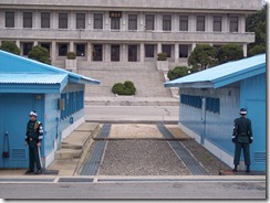
We were fortunate to be able to see the Military Armistice Commission building as tensions have been high between the North and the South. In part due to a Southern Korean ship that was suspected to be sunk by the North. The blue building to the left is the MAC building where the North and the South have negotiations. The small cement curb between the gravel and the pavement marks the Military Demarcation Line between the Republic of Korea (South) and the Democratic People's Republic of Korea (North).

We could clearly see a soldier from the North who had initially been watching us through binoculars. It was a very odd feeling, especially after signing a form that indicating our understanding that we could be harmed or killed on this tour.

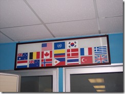
The North does things to antagonize the South. Such as, using the American flag from this display to shine their boots and the South Korean flag to blow their nose. The North has also rearranged the furniture on the Southern half of the MAC building. They have also walked barefoot on the tables in the Southern half which is a sign of disrespect. A footprint can still be seen on the table and cannot be removed through cleaning.

This South Korean soldier, who is standing in a modified Tae Kwon Do ‘ready’ stance, is actually standing in North Korea. I, too, crossed the room and stood in communist North Korea.

We were then taken to Checkpoint 3 where we had an excellent view of the North Korean and ‘Propaganda Village.’ Given this name from South Korea because of the blaring messages from loud speakers praising the North and Kim Jong Il. It is also been established that no one actually resides in Propaganda Village, although the North will deny this. The flagpole seen in this photo is the World’s largest and the North Korean flag flying weighs over 600 pounds!!

Monument erected to the two American Soldiers slaughtered and mutilated with axes by the North Korean Soldiers during a routine tree trimming event.

After the Armistice was signed, soldiers from both sides were returned to the Bridge of No Return. They could chose to which side of Korea they wished to return; but, once there they were not allowed to cross back over into the opposing side again.

This is a satellite photo of both Koreas. It’s terribly eerie how incredibly dark it is on the North Korean side. Only one solitary dot illuminated at North Korean capital of Pyonyang. Photo from Strange Maps.

Thank you for staying with me on my journey to the DMZ, I know this was a long post. It was a moving experience for me. It brought back fears from the Oklahoma City bombing, pride in my husband for helping to protect a proud nation, compassion in my soul for a nation ripped in two, heartbreak for amazing people working to rebuild their homeland, sorrow for the children born in the communist North and wonder that I was able to experience it all. How blessed I am!

Wow, almost no electricity in N Korea, rather sad they are so far behind the south!
ReplyDeleteYou've very brave! I'm glad to see the pictures and hear the story from the relative safety of my bedroom. Thanks for sharing!
ReplyDeleteWOW!!! Great pics & narration!! I've always wondered about the Korea's & DMZ cuz my Dad fought in Korea. I'm so happy for you to be able to do something you really enjoy (travel)despite knowing it could make the rest of your week very difficult!
ReplyDelete